Cyclists’ dream of crossing Bay Bridge moves forward on slow, pricey roll

The dream of riding a bicycle across the wind-beaten, 4.5-mile span of the Bay Bridge is inching closer to reality, as engineers roll out designs and advocates scramble to secure hundreds of millions of dollars in funding by 2022.
“As recently as four or five years ago, it was a vision that didn’t have a timetable or plans associated with it, but I think that’s changed,” said Brian Wiedenmeier, executive director of the San Francisco Bicycle Coalition.
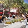
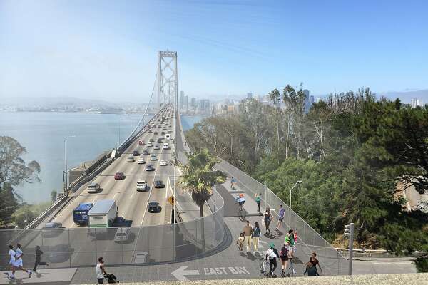
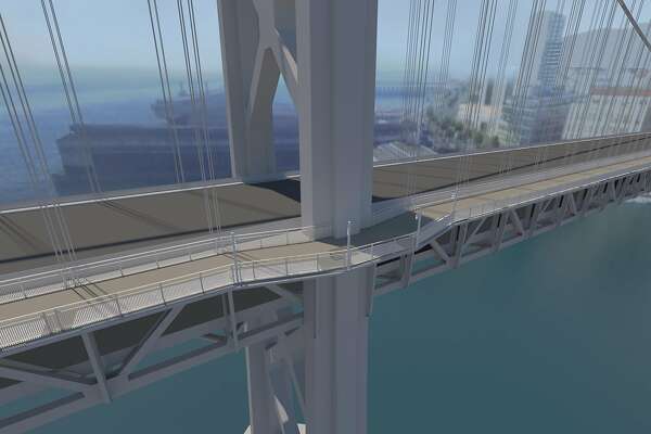
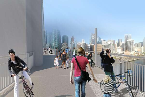
Plans will come into focus Monday, when the project team releases its preferred concept to the public: a route along the north side of the west span, from Southgate Road on Yerba Buena Island, to Essex Street at the lip of downtown San Francisco. Engineers will display renderings and discuss challenges Monday evening at the Bay Area Metropolitan Transportation Commission headquarters.
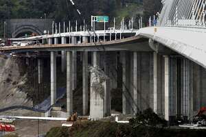
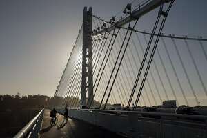
Bike paths are catching on as a form of transbay commuting. In 2013, officials opened a partial trail along the eastern span — from Shellmound Street in Emeryville to an end point just past the 525-foot suspension tower — extending it to Yerba Buena Island four years later. Construction is under way on a similar path that would snake along the upper deck shoulder of the Richmond-San Rafael Bridge. It’s expected to open in March.
The Bay Bridge west span bikeway is a more intricate and complicated beast, and it may take a decade to complete. Once officials find the money — probably a mix of Regional Measure 3 tolls and state SB1 gas tax funds — they face three or four years of preliminary designs and environmental review, two years of final design and right-of-way acquisition and four years of construction. The path would have to withstand blistering ocean winds and earthquakes, wind around a housing development planned on Yerba Buena Island, and retain the current height of the bridge so that ships could pass beneath it.
“This is the San Francisco Bay Area, and we do not have a habit of getting big projects completed quickly,” Wiedenmeier said. But he hinted that pressure to build the path will grow, given the exploding population and the urgency to meet climate goals. Last week BART began pressing plans for a second Transbay Tube, also on an aggressive 10-year timeline.
“I think the pressure from any number of angles is growing to increase options for how to get across the bay,” said Robert Raburn, president of BART’s Board of Directors and a former leader of the East Bay Bicycle Coalition, which began touting ideas for a Bay Bridge bike path as far back as the mid-1990s, when the bridge’s new eastern section was still in its embryonic phase.
By 2001, Raburn thought they’d hit on a good design for the west span path: lightweight asphalt with shims to lift up the cables, so the structure wouldn’t sag. But they never rallied enough money to pursue it, Raburn said. A cheaper idea to ration traffic lanes on the bridge and thread a bike lane through the middle also died because it lacked political will.
It proved easier to build a bike trail from scratch on the replacement eastern span. And once that opened, the idea of extending it all the way to the Embarcadero seemed more viable, Wiedenmeier said. Because the new design would attach the bike path to the north side of the existing west span — leaving the upper-deck lane configuration intact — it’s unlikely to face motorist opposition. It would also serve as a roadway for maintenance vehicles so they don’t clog traffic.
In the next few years, Caltrans and the Metropolitan Transportation Commission will probably replace the asphalt on the bridge’s western upper deck, which could present an opportunity to build the bike path.
“Conceivably, a roadway of lighter material could offset the weight of the path,” said commission spokesman John Goodwin.
Planners estimate that 10,000 cyclists and pedestrians will traverse the bikeway each day, matching the number of cars crossing the bridge during a peak hour. Commuters could bike between Oakland and San Francisco in about 45 minutes, and residents of a proposed Treasure Island mega-development could bike home using the paths that split off Yerba Buena Island.
“Market Street gets several thousand drivers each day, so this would be on that magnitude,” said Dave Campbell, advocacy director of Bike East Bay. Like others, he views the future Bay Bridge Bike Path not only as a solution for the region’s jammed freeways and overstressed BART system, but as a tourist attraction.
“The views will be spectacular,” he said, referring to a wide vista of the bay’s choppy waters, the preening skyscrapers along San Francisco’s shoreline, and the bridge’s suspension tower looming overhead.
“One thing I know for sure is we’ll look back and be glad we built this thing,” he said.
Rachel Swan is a San Francisco Chronicle staff writer. Email: rswan@sfchronicle.com Twitter: @rachelswan